SPONSORS
BECOME A
SPONSOR
We have 4 different
levels of sponsorship
that are available.We
believe that this site
will generate traffic
leads for your business
and since we are just
starting we have some
great rate plans.
Contact Rocko’ for
further information.


SWDeserts / Desert Magazine SW / My DesertMagazine LLC All Rights Reserved © 1937-2022


MOJAVE DESERT
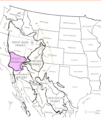
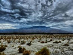
The Mojave Desert (pronounced: /mɵˈɑːiː mo-hah-vee) is a rain shadow, mostly high desert area, that
occupies a significant portion of southeastern California and smaller parts of central California, southern
Nevada, southwestern Utah and northwestern Arizona in the United States. The term Mojave originates
from the Spanish language while the spelling Mohave comes from modern English. Both are used today,
although the Mohave Tribal Nation officially uses the spelling Mojave; the word is a shortened form of
Hamakhaave, their endonym in their native language, which means 'beside the water'. The Mojave Desert
displays typical basin and range topography. Higher elevations above 2,000 feet (610 m) in the Mojave are
commonly referred to as the High Desert; however, Death Valley is the lowest elevation in North America at
282 feet (86 m) below sea level and is one of the Mojave Desert's more notorious places.
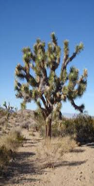
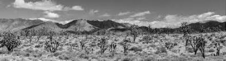
The Mojave Desert's boundaries are generally defined by the presence of Yucca brevifolia (Joshua trees),
considered an indicator species for this desert. The topographical boundaries include the Tehachapi
together with the San Gabriel and San Bernardino mountain ranges. The mountain boundaries are quite
distinct since they are outlined by the two largest faults in California, the San Andreas and Garlock faults.
The Great Basin shrub steppe lies to the north, and the warmer Sonoran Desert (the Low Desert) lies to the
south and east. The desert is believed to support between 1,750 and 2,000 species of plants.
While most of the Mojave Desert is sparsely populated, several large cities can be found there including
Lancaster, Palmdale and Victorville in California, as well as Henderson and Las Vegas (the largest) in
Nevada. There are some research facilities at Mojave Airport (also known as Mojave Air and Space Port),
located within Mojave Desert.
Climate
The Mojave Desert receives fewer than 13 in (330 mm) of rain a year and is generally between 2,000 and
5,000 feet (610 and 1,520 m) in elevation. The Mojave Desert also contains the Mojave National Preserve;
as well as the lowest and hottest place in North America: Death Valley at 282 feet below sea level; where
the temperature often surpasses 120 °F (49 °C) from late June to early August. Zion National Park in Utah
lies at the junction of the Mojave, the Great Basin Desert, and the Colorado Plateau. Despite its aridity, the
Mojave (and particularly the Antelope Valley in its southwest) has long been a center of alfalfa production;
fed by irrigation coming from groundwater and (in the 20th century) from the California Aqueduct.
The Mojave is a desert of temperature extremes and two distinct seasons. Winter months brin temperatures
dipping to around 20 °F (− °C) on valley floors, and below 0 °F (−8 °C) at higher elevations. Storms moving
from the Pacific Northwest can bring rain and in some places even snow. More often, the rain shadow
created by the Sierra Nevada as well as mountain ranges within the desert such as the Spring Mountains,
bring only clouds and wind. In longer periods between storm systems, winter temperatures in valleys can
approach 80 °F (27 °C). Spring weather continues to be influenced by Pacific storms, but rainfall is more
widespread and occurs less frequently after April. By early June, it is rare for another Pacific storm to
have a significant impact on the region's weather; and temperatures after the middle of May are normally
above 90 °F (32 °C) and frequently above 100 °F (38 °C).Summer weather is dominated by heat.
Temperatures on valley floors can soar above 120 °F (49 °C) and above 130 °F (54 °C) at the lowest
elevations. Low humidity, high temperatures, and low pressure, draw in moisture from the Gulf of Mexico
creating thunderstorms across the desert southwest known as the North American monsoon. While the
Mojave does not get nearly the amount of rainfall that the Sonoran desert to the south receives, monsoonal
moisture will create thunderstorms as far west as California's Central Valley from mid-June
through early September. Autumn is generally pleasant, with one to two Pacific storm systems creating
regional rain events. October is one of the driest and sunniest months in the Mojave; and temperatures
usually remain between 70 °F (21 °C) and 90 °F (32 °C) on the valley floors. After temperature, wind is the
most significant weather phenomenon in the Mojave. Across the region windy days are common; and also
common in areas near the transition between the Mojave and the California low valleys, including near
Cajon Pass, Soledad Canyon and the Tehachapi areas. During the June Gloom, cooler air can be pushed
out into the desert from Southern California. In Santa Ana wind events, hot air from the desert blows out into
the Los Angeles basin and other coastal areas. Wind farms in these areas generate power
from these winds.The other major weather factor in the region is elevation. The highest peak within the
Mojave is Charleston Peak at 11,918 feet (3,633 m); while the Badwater Basin in Death Valley is 282 feet
(86 m) below sea level. Accordingly, temperature and precipitation ranges wildly in all seasons across the
region. The Mojave Desert has not historically supported a fire regime because of low fuel loads and
connectivity. However, in the last few decades, invasive annual plants (e.g., Bromus spp., schismus spp.,
Brassica spp.) have facilitated fire; which has significantly altered many areas of the desert. At higher
elevations, fire regimes are regular but infrequent.
Geography
The Mojave Desert is defined by numerous mountain ranges creating its xeric conditions. These ranges
often create valleys, endorheic basins, salt pans, and seasonal saline lakes when precipitation is high
enough. These mountain ranges and valleys are part of the Basin and Range province and the Great Basin;
a geologic area of crustal thinning which pulls open valleys over millions of years. Most of the valleys are
internally drained (endorheic basins), so all precipitation that falls within the valley does not eventually flow
to the ocean. Some of the Mojave (toward the east, in and around the Colorado River/Virgin River Gorge) is
within a different geographic domain called the Colorado Plateau. This area is known for its incised
canyons, high mesas and plateaus, and flat strata; a unique geographic locality found nowhere else on
earth.
Parks and Tourism
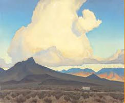
The Mojave Desert is one of the most popular tourism spots in North America, primarily because of the
gambling destination of Las Vegas. The Mojave is also known for its scenic beauty, with three national parks
– Death Valley National Park, Joshua Tree National Park, and the Mojave National Preserve. Lakes Mead,
Mohave, and Havasu provide water sports recreation, and vast off-road areas entice off-road enthusiasts.
The Mojave Desert also includes a California State Park, the Antelope Valley California Poppy Reserve,
located in Lancaster. Hoover Dam is a popular tourist destination. Visitors get a chance to see the structure,
the hydroelectric power plant, and hear the history of the dam's construction during the Great Depression.
Besides the major national parks, there are other areas of identified significance and tourist interest in the
desert such as the Big Morongo Canyon Preserve, within the Colorado Desert, and the Red Rock Canyon
National Conservation Area, 17 miles (27 km) west of Las Vegas, both of which are managed by the Bureau
of Land Management.
Among the more popular and unique tourist attractions in the Mojave is the self described world's tallest
thermometer at 134 feet (41 m) high, which is located along Interstate 15 in Baker, California. The newly
renovated Kelso Depot is the Visitor Center for the Mojave National Preserve. Nearby the massive Kelso
Dunes are a popular recreation spot. Nipton, California, located on the northern entrance to the Mojave
National Preserve, is a restored ghost town founded in 1885.
Several attractions and natural features are located in the Calico Mountains. Calico Ghost Town, in Yermo,
is administered by San Bernardino County. The ghost town has several shops and attractions, and inspired
Walter Knott to build Knott's Berry Farm. The BLM also administers Rainbow Basin and Owl Canyon, two
"off-the-beaten-path" scenic attractions together north of Barstow in the Calicos. The Calico Early Man Site,
in the Calico Hills east of Yermo, is believed by some archaeologists, including the late Louis Leakey, to
show the earliest evidence with lithic stone tools found here of human activity in North America. The Calico
Peaks scenically rise above all the destinations.
A tour of the Mojave Desert inspired American songwriter Carrie Jacobs-Bond to compose the parlor song
"A Perfect Day" in 1909.
Cities and Regions
While the Mojave Desert itself is sparsely populated, it has increasingly become urbanized in recent years.
The Mojave metropolitan areas include: Las Vegas, which is the largest city in the Mojave with a
metropolitan population of around 1.9 million in 2006; Lancaster, the largest California city in the desert; and
over 850,000 people live in areas of the Mojave attached to the Greater Los Angeles metropolitan area,
including Palmdale and Lancaster, (referred to as the Antelope Valley), Victorville, Apple Valley and
Hesperia (referred to as the Victor Valley) attached to the Inland Empire metropolitan area, the 14th largest
in the nation; and St.George in the northeastern-most part of the Mojave.
Smaller cities or micropolitan areas in the Mojave Desert include Lake Havasu City, Kingman, Laughlin,
Bullhead City and Pahrump. All have experienced rapid population growth since 1990.
Towns with fewer than 30,000 people in the Mojave include: Barstow, Boron, California City, Joshua Tree,
Lone Pine, Mojave, Needles, Nipton, Pioneertown, Randsburg, Ridgecrest, Rosamond and Twentynine
Palms in California; Mesquite and Moapa Valley in Nevada; and Hurricane in Utah.
The California portion of the desert also contains Edwards Air Force Base and Naval Air Weapons Station
China Lake, noted for experimental aviation and weapons projects, and the largest Marine Corps base in
the world at Twentynine Palms. The US Army also maintains Fort Irwin & the National Training Center
(NTC) which is another major training area for the United States Military. Mojave airport is also home to a
long term storage facility for large airplanes due to extremely dry non-corrosive weather conditions and a
hard ground ideal for parking aircraft. The airport also houses the Air and Space Port and was one of the
test centres for the Virgin Galactic Fleet.
The Mojave Desert contains a number of ghost towns, the most significant of these being the gold-mining
town of Oatman, Arizona, the silver-mining town of Calico, California, and the old railroad depot of Kelso.
Some of the other ghost towns are of the more modern variety, created when U.S. Route 66 (and the
lesser-known U.S. Route 91) were abandoned in favor of the Interstates. The Mojave Desert is crossed by
major highways Interstate 15, Interstate 40, U.S. Route 95, U.S. Route 395 and California State Route 58.
Other than the Colorado River on the eastern half of the Mojave, few long streams cross the desert. The
Mojave River is an important source of water for the southern parts of the desert. The Amargosa River flows
from the Great Basin Desert south to near Beatty, Nevada, then underground through Ash Meadows before
returning to the surface near Shoshone, California, disappearing underground again a short while later and
has its final outlet into the southern end of Death Valley. The riverbed passes under SR 127 near Dumont
Dunes before turning north into Death Valley National Park.
The Mojave Desert is also home to the Devils Playground; about 40 miles (64 km) of dunes and salt flats
going in a northwest-southeasterly direction. The Devils Playground is a part of the Mojave National
Preserve and is located between the town of Baker, California and Providence Mountains. The Cronese
Mountains are found within the Devils Playground.
Text is available under the Creative Commons Attribution-ShareAlike License; additional terms may apply.Wikipedia® is a registered trademark
of the Wikimedia Foundation, Inc., a non-profit organization.


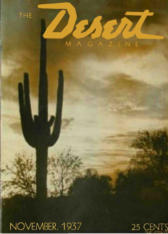
Desert Adventures & Exploring....Since 1937

OF THE SOUTHWEST